PGWA Creates Custom AVA Wine Maps Using Google Maps

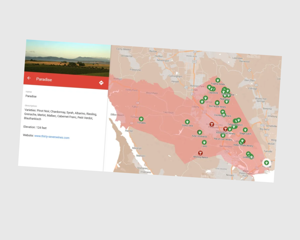
The Petaluma Gap Wine Growers Alliance (PGWA) has been working with an illustrator to develop a more intricate digital and printable AVA map. While this project in progress, the Alliance wanted something temporary on the website and quickly created a custom and free AVA map using Google My Maps.

Here are the steps to follow in creating a map of a particular AVA:

Step 1 – Create A New Map – Access the Google My Maps website and sign in with your Google account. You’ll need to create an account if you don’t have one yet.  Once logged in, click the “+ Create a new map” button to initiate the map-building process.

Step 2 – Personalize Your Map – At the top left corner of the page, locate the “Untitled map” field. You can enter your organization’s name.

Step 3- Define Your Boundary – Download an SHP (shape) of your AVA boundary as defined by the federal government from the TTB website. Since Google Maps only supports KML files, you must convert the SHP using geographical information software (GIS). For instance, we used the open-source GIS application QGIS for this purpose. Import the converted KML file into Google Maps as your initial layer.

Step 4 – Map Wineries – Create an additional layer for wineries. Utilize the search function to locate wineries by name or address. Click the “Add to map” option in the toolbar. If a winery has claimed its business on Google, relevant information will appear in the drop-down menu. Choose or customize the marker icon, such as a wine glass or grape icon.

Step 5 – Plot the Vineyards – PGWA has employed latitude and longitude coordinates to locate vineyards. Since only a few vineyards were registered as businesses on Google, they manually inputted information, including vineyard photos, a list of cultivated grape varieties, and elevations. Non-grower members were identified on the map with less detailed information.

Step 6- Organize Your Layers – You can enhance your map by creating multiple layers. This helps in segregating distinct categories of data. Click the “Add layer” button in the left sidebar to establish a new layer. In our case, separate layers were used for wineries, vineyards, and members and non-members.

Step 7 – Share Your Map – The map can be shared using a unique link, making it accessible to specific individuals or made public or private.  Most importantly, you can embed code to easily incorporate the map into your website or blog.

This serves as a valuable tool for wine organizations and wine professionals in showcasing vineyards and tasting rooms within the geographical boundaries.

Source:  Wine Data Researcher

Arizona adds another viticulture area “Verde Valley” 

Arizona’s Verde Valley is often referred to as the state’s second Grand Canyon. It now has a new distinction as an American Viticultural Area designating the unique geography, topography, soils, and climate as a recognized grape growing area.

Now the third AVA in Arizona, Verde Valley joins Sonoita and Willcox.  Verde Valley Wine Consortium president Tom Schumacher, first submitted a petition in 2017, called it a reason to cheer and “a fruitful end to an arduous effort.”

Michael Pierce, director of Viticulture and Enology at Yavapai College, adds: “It was five years in the making, so we’re very relieved it’s finally accomplished.”

Located in the geographic center of the state, the Verde Valley AVA encompasses about 220 square miles near Oak Creek and the Verde River. The Verde Valley Wine Trail shows 19 commercial vineyards farming 135-plus acres of wine grapes with another 25 acres planned for upcoming planting. The region boasts 25 tasting rooms.

Today, vineyards in the AVA grow over 40 wine grape varieties from Malvasia Blanca, Viognier, and Chardonnay on the white side to reds like Syrah, Petite Syrah, and Cabernet Sauvignon.

The AVA is surrounded by higher elevations and steeper slopes like the Mogollon Rim and the Black Hills. “Verde Valley AVA’s topography positively affects viticulture,” according to published reports.

“The gentle slopes allow for easier vineyard management as cooler air draining from the higher elevations provides a diurnal temperature swing that slows the maturity of wine grapes, extends the growing season, and leads to more complex wine flavors.”

#Arizonawine #AZwine #Arizona #vineyard#VerdeValleyWineConsortium #AVA #wine #winelovers #winecountry #USWine #winenews #Arizonawinecountry @VerdeValleyWineConsortium

SLO County (California) gets a new AVA

The SLO Coast Wine Collective announced this week that the San Luis Obispo Coast has been recognized as the newest American Viticultural Area (AVA) by the US Alcohol and Tobacco Tax and Trade Bureau.

Previously home to four AVAs: Paso Robles, Arroyo Grande, Edna Valley and York Mountain — SLO County has not had a new region approved for 30 years, since Arroyo Grande was last awarded the title in 1990.

The new AVA is a long, narrow strip of land that runs along California’s Central Coast, is 60 miles long and 15 miles wide. Currently, there are 32 wineries, that applied for the official status in 2017, making a case for the area’s unique and regional-specific characteristics including its proximity to the Pacific Ocean.

The SLO Coast AVA also includes 78 vineyards and around 4,000 acres under vine, with Chardonnay and Pinot Noir being the most dominant plantings, alongside Albariño, Grüner Veltliner, Riesling, Grenache, Syrah, Tempranillo and Zinfandel.

“We are one of the coldest spots to grow grapes because we are so close to the Pacific Ocean,” said SLO Coast Wine president Stephen Dooley. “What makes this area interesting is the low temperatures coupled with a lot of sunlight. Cool temperatures preserve acid, and in grapes like Pinot Noir, the sun helps with pigment, colour and tannin.”

#winenews #wine #redwine #whitewine #winelovers #vineyards #AVA #californiawines #cagrown #californiawinecountry #winecountry #californiawineries #winetravel #winetravels #winetraveler #viticulture #slocoastwine #slowine #coolclimatewine

Washington to gain six new AVAs in 2020

Washington will be gaining six additional AVAs to its current fourteen, as part of the state’s fast-growing wine industry.

Doug Marshall, Senior Marketing Manager at Washington State Wine Commission is hopeful that the new AVAs will become a reality over the next six to 12 months. The region reached 1,000 wineries a few months ago, having grown from 200 in 2003.

“The growth has been pretty substantial, and we believe a lot of that growth comes down to quality,” Marshall told Harpers.  As an emerging region with only 20 to 30 years of winemaking experience, he added, Washington is now beginning to get into its stride, with a better understanding of its potential sub-regions, climate, and terroir.”

The new proposed AVAs include: The Burn, White Bluffs, Candy Mountain, Goose Gap, and Royal Slope.

“We know more about the region now, so we are understanding where boundaries are, recognizing regions… the new AVAs, and one of reasons we are seeing so many with six in the works, is that we are really honing our region in” states Marshall, and

“As people become more willing to explore and explore something they don’t know, [with] any wine region that is primarily premium, that gives us a leg up because that is our world,” he said by way of explaining the ongoing expansion of Washington’s winemaking scene.”

He further adds that “as a young region with just “20 to 30 years of winemaking tradition, Washington and its producers, including an influx of younger, second-generation winemakers, is now beginning to get more fully into its stride – understanding its potential sub-regions, soils, and climates.”